The Wash Habitat Mapping Videos
The videos (below) taken by Seasearch divers give us a glimpse of some of the habitats and species that are commonly found in The Wash and demonstrate how patchy habitats can be spatially. Both dives detailed below were drift dives and so the speed of the video footage indicates the strength of the current at the time, highlighting how strong it can be in areas of The Wash.
Video 1: West of Sunk sand (click here to go to video link)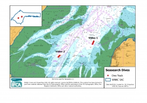
Predominantly sandy sediments with patches of Sabellaria reef and sand ripples and some areas of sand over mud.
Video 2: East of Gat Sand (click here to go to video link)
More consistent sand and muddy sediment with shell, this kind of sediment could potentially be classed as mixed sediment however subsequent particle size analysis showed the fraction of mud and gravel sediments were not quite high enough to be mixed.
EIFCA carry out regular habitat mapping surveys to improve our understanding of the spatial distribution of habitats within The Wash and to inform management measures that are introduced to protect features sensitive to certain fishing activities. These two surveys were initially conducted to support the identification of a site for the proposed shrimp impact study and have since been fed into EIFCA’s 2016 and 2017 Habitat Mapping Report and review of red-risk restricted areas.