Natural Disturbance Study
Background
Whilst it is understood that chalk damage is irreversible, the MCZ is known to experience strong natural forces, such as waves, tides, and storm surges, which can degrade chalk naturally. The Natural Disturbance study aims to compare levels of chalk erosion and degradation in areas where no potting occurs with areas that experience typical levels of potting. This will enable a better understanding of the rate and scale of potting impacts across the site as well as their significance against background levels of disturbance. The outcomes of this study will inform Adaptive Risk Management by providing the evidence required to develop appropriate and proportionate management.
Development of the Study Design
An initial proposal was developed by Blue Marine Foundation in 2022 in collaboration with fisherman. The proposal was further developed by the Research and Development Task and Finish Group with expert input from academics, fishermen and conservation advisors among other interested stakeholders, to ensure it was practically achievable with the resources available.
The final study design includes repeat surveying across six experimental areas containing rugged chalk (each 150 x 150m), three of which are open to potting and three closed to potting, for a minimum of three years. Closed areas include a buffer of 40m to prevent any accidental drift of pots into the experimental area and were established in September 2023.
The location of the study areas was informed by existing habitat data as well as the collection of additional data during the summer of 2023 to ensure areas contained sufficient rugged chalk features. Survey techniques were also trialled during this period to ensure their suitability and achievability. Whilst the original proposal included dive surveys, these were subsequently removed due to the required sample size being unachievable with the resources available.
The development of the final proposal, the identification of study areas and the outcome of survey trials is detailed in the 2024 Natural Disturbance Study Year 1 report. The project continues to be developed and revised over time to ensure robustness whilst staying in budget and within expected time scales.
In 2025 an independent review of the study was commissioned to ensure it is sufficiently robust to achieve its primary aim. Whilst this review concluded the study as fit for purpose and capable of addressing the key research question, it recommended some opportunities to strengthen the approach. The findings of the review are being considered by the Research and Development Task and Finish Group and proposals for adopting where feasible will be put to the Project Board with a view to further strengthening the study. For more information on the review please see:
- APEM Natural Disturbance Study Independent Review 2025 – Final Report
- APEM Natural Disturbance Study Independent Review 2025 – Eastern IFCA summary
Survey methods
Experimental areas will be surveyed at least once a year for a minimum of three years using two methods:
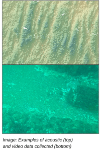
Acoustic surveys collecting high resolution multibeam, backscatter and side scan data across each experimental area. Completed in spring and autumn.
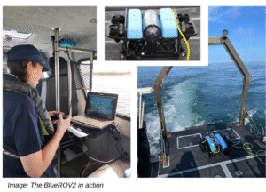
ROV seabed video surveys collecting downward facing camera video footage and stereo imagery along three 150m transects per experimental area. Completed between June and September.
In addition to the above, fishing activity data and environmental conditions (weather and tidal) are being monitored by Eastern IFCA.
Information for Fishers
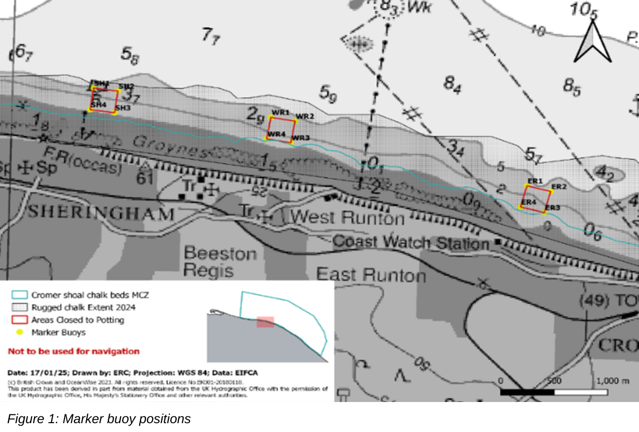
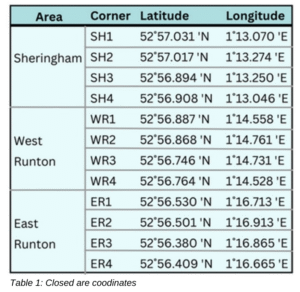
Three mandatory closures are in place between Sheringham and Cromer and prohibit both commercial and recreational potting activities. Closed areas are detailed in Figure 1 below and co-ordinates are provided in Table 1.
Please click here to download shapefiles of the closed areas.
Marker buoys have been placed on all four corners of the closed areas (Figure 1). These markers are indicative only and only mark out the approximate area of each closed area. It is advised that pots are not set in close proximity to the marker buoys and fishermen use plotters and the coordinates provided to ensure they are compliant with the closure.
Closed Area Management
Closed areas are in place as part of the Natural Disturbance Study. Potting is prohibited in these areas so they can act as control areas to compare damage to chalk against areas where potting is allowed. It is hoped that this will help identify how much damage is from natural causes compared to potting
The areas are monitored through a combination of monitoring vessel movements (either through Inshore Vessel Monitoring Systems or trackers provided by the Authority) and regular shore-based and seaborne patrols. Where potential incursions are detected or reported, officers visit the site to undertake an inspection, identify any non-compliant fishing gear and take appropriate actions, including the removal of the fishing gear if necessary.
A small number of incursions into some of the closed areas occurred during 2024, these were investigated and ultimately led to the implementation of mandatory measures to replace what was a voluntary code to ensure the areas are not subject to potting activity. The Authority investigated the extent to which the incursions would detrimentally impact the study and concluded that the activity was not sufficient to undermine the study. A full report on the incursions is available at the link below.
For further information about the project please see:
2.3 Natural disturbance study, 2023 CSCB MCZ ARM Interim report (page 16)
2024 Natural Disturbance Study Year 1 report
2024 Closed Area Incursion Report
Cefas Natural Disturbance Study Interim Analysis 2026 – Final Report
Cefas Natural Disturbance Study Interim Analysis 2026 – Eastern IFCA summary
Any questions and for additional information about the study please contact us or email:
samanthahormbrey@eastern-ifca.gov.uk