Research Update: Preliminary observations and examples of BlueROV 2 footage showing different habitats in the Cromer Shoal Chalk Beds MCZ

Our BlueROV 2.
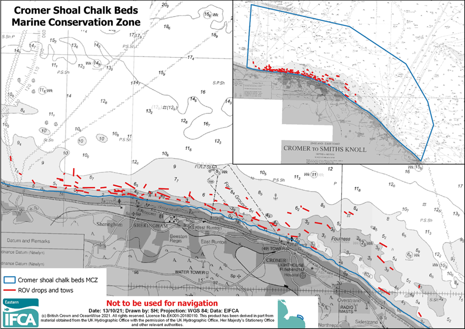
Since purchasing our new BlueROV 2 in July this year we have completed eight days of video surveys, collecting seabed footage at 87 different locations within the Cromer Shoal Chalk Beds MCZ (see chart below). Surveys have included towing the ROV above the seabed to provide valuable information on the location and structure of outcropping chalk features. We have also flown the ROV along shanks of pots to help us understand how potting gears interact with chalk features and allow us to identify and assess instances of damage.
Several of the videos collected using the ROV can be seen below. We’re sharing these to provide examples of the different types of habitats encountered within the MCZ and to demonstrate how pots interact with the chalk feature.
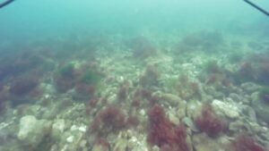
Still taken from seabed footage.
What we have seen so far:
– The extent of the rugged chalk feature appears smaller than previously thought, and tends to be situated in a band close to shore.
– In most instances where gear has been seen, there hasn’t been any noticeable damage.
– The ground ropes seen generally sit off the seabed, up to about 1m, but this may be prevented if pots are deployed with the lines being tight.
– Most of the instances where damage has been observed, it has been caused by the ropes coming into contact with raised chalk features.
– The pots themselves don’t appear to damage the chalk feature very much.

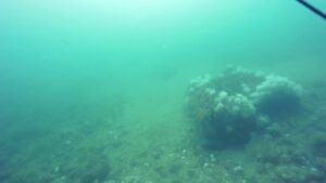
Still showing parlour pot interacting with the seabed.
– We have seen instances of lost pots, but not very many.
Next steps:
– Continue collecting seabed imagery using the ROV in areas where there is still uncertainty about the presence of rugged chalk so that we can map its extent with confidence.
– Continue collecting imagery of shanks of pots in the water to understand what parts of the gear are responsible for causing damage and how often damage occurs. This will help us determine whether the level of damage is preventing the chalk from supporting its biological communities.
Still showing two lost pots covered in growth.
– As required, develop measures with stakeholders to ensure that the conservation objectives of the MCZ are being met.
We will provide updates on this work as it progresses, through our Cromer Shoal Chalk Beds MCZ webpage.
| Description of Video | Location |
|---|---|
| Survey date: 04/08/2021 Here we are towing the ROV off Overstrand over what appears to be hard ground. For the first half of the video the seabed is dominated by chalk and flint pebbles and cobbles and whilst not completely flat, there is very little elevation in terms of outcropping chalk features. During the second half of the video the seabed gradually changes to large areas of mobile sand interspersed with areas of pebble, cobble and boulders but, again, with limited elevation. This sand may be overlaying hard ground, however, it is impossible to know for certain from the video. The video shows no evidence of anthropogenic damage to chalk features. Video Link: Click here for Video 1 |  |
| Survey date: 04/08/2021 In this video, also taken off Overstrand, the seabed is formed of exposed chalk bedrock with areas overlain with sediment, pebbles and cobbles. Whilst there is some outcropping chalk forming small gullies and ridges, the level of elevation is relatively low and the video shows no evidence of anthropogenic damage to chalk features. To be more confident in estimating the size of features encountered in the videos, we have purchased some lasers which will be attached to the ROV on future surveys and will provide a known scale to be able to take measurements from. Video Link: Click here for Video 2 | 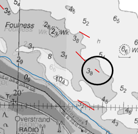 |
| Survey date: 05/08/2021 The habitat in this video, taken to the west of Sheringham, starts off as being similar to stony reef: the seabed is dominated by sand, cobbles and pebbles and is rich in fauna, both mobile and attached. In this video you can see numerous crabs, a lobster, sea anemones, starfish and small fish, amongst a faunal turf of hydroids, bryozoans and sponges. Towards the middle of the video the fauna becomes sparse as larger areas are dominated by sand with areas of pebble/cobble, eventually turning to a mobile sand seabed. The video shows no evidence of outcropping chalk in this area. Video Link: Click here for Video 3 | 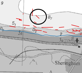 |
| Survey date: 05/08/2021 In this video taken in very shallow water off Sheringham we have areas of rugged seabed made up of elevated outcropping chalk amongst areas of flatter ground dominated by pebbles and cobbles. Some of the elevated chalk features show signs of damage: areas of bright white chalk that appear to have broken away. It is impossible to know whether these are the result of anthropogenic activity or natural disturbance. The chalk bed occurs in a high energy environment where loose pebble, cobbles and even boulders can be moved by currents resulting in this type of damage. Furthermore, these instances do not reflect the types of damage we generally see from ropes (see video 5). In this video the chalk feature supports a biological community dominated by algae. Video Link: Click here for Video 4 | 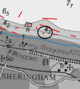 |
| Survey date: 17/09/2021 On this occasion, taken off Cromer, weather and tidal conditions allowed us to fly the ROV rather than tow it. This meant we had much greater control, giving us the ability to follow a shank of pots without risking becoming snagged with the gear. The video shows an area of rugged outcropping chalk with gullies and ridges amongst flatter areas of chalk pavement overlain with sediment, pebbles, cobbles, and some boulders. As we follow the shank, you can see that for most of the video the ground rope sits up to about 1m of the seabed, however, there are instances where the rope doesn’t float high enough to clear some of the elevated features, instead coming into contact with the chalk and cutting or abrading the surface. This generally seems to happen where a pot has landed in a gully or next to a high feature and provides clear evidence of damage to the chalk feature which can be attributed to the pot ropes. However, these instances are highly localised and limited in frequency, thus, we need to understand if this level of impact is preventing the function of the chalk to support its biological communities. There is no clear evidence from this video which suggest that the pots themselves cause damage to the chalk feature. There are some other incidents of potential damage (small patches of white chalk) observed in the video, however, we cannot be certain at this time of the cause of these incidents. Video Link: Click here for Video 5 | 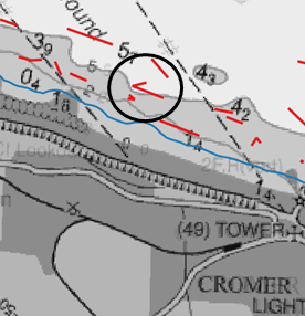 |
| Survey date: 16/09/2021 Here we flew the ROV off West Runton along a shank of pots all the way to the anchor and were able to bring the ROV right up to each pot and assess for any evidence of anthropogenic damage. The seabed is formed of chalk bedrock outcropping in patches, with areas of overlying sediment and other areas of pebbles, cobbles and boulders. Whilst there is some elevation where these features and boulders occur the seabed is relatively flat and is not considered rugged chalk. No evidence of anthropogenic damage to chalk features was observed in this video. Video Link: Click here for Video 6 | 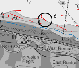 |