Cromer Shoal Chalk Beds MCZ Interim Measures
As part of the management of crab and lobster potting within the Cromer Shoal Chalk Beds Marine Conservation Zone (MCZ), the Authority has brought into effect two interim measures. Both measures are intended to be temporary and will facilitate the delivery of Adaptive Risk Management of the MCZ.
1. Byelaw 11 (Development of shellfish fisheries): Beach launched vessels within the Cromer Shoal Chalk Beds MCZ
All beach launched vessels fishing within the Cromer Shoal Chalk Beds MCZ using pots for crab and lobsters must provide location information every 3 minutes under Byelaw 11: Development of shellfish fisheries.
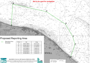
The Cromer Shoal Chalk Beds Area is defined as the area of the District landward of the line drawn by a continuous series of points shown in the figure below.
The means by which the positional data is provided may include, but is not limited to:
 – From trackers provided by the Authority; or
- – From Inshore Vessel Monitoring System devices issued by the Marine Management Organisation.
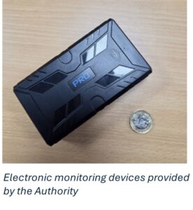
The Authority will provide electronic monitoring devices which are capable of transmitting this da
ta free of charge.
The full wording of the requirement can be found here: Fisheries Positional Data Requirement
2.Byelaw 8: Temporary closure of shellfish fisheries: Natural Disturbance Study areas
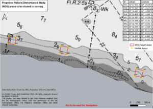
The three closed areas (between Sheringham and Cromer) for the Natural Disturbance Study are temporarily closed to both commercial and recreational potting activities under Byelaw 8: Temporary Closure of Shellfish Fisheries Byelaw.
Potting is prohibited in these areas so they can act as control areas to compare damage to chalk against areas where potting is allowed. It is hoped that this will help identify how much damage is from natural causes compared to potting for the purposes of gathering evidence to support Adaptive Risk Management within the MCZ.
Marker buoys have been placed on all four corners of the closed areas (Figure 1). These markers are indicative only and only mark out the approximate area of each closed area. It is advised that pots are not set in close proximity to the marker buoys and fishermen use plotters and the coordinates provided to ensure they are compliant with the closure.
Please click here to download shapefiles of the closed areas.
The full wording of the requirement (including the area the measure applies in) can be found here: Temporary Closure notice
Development of interim measures
A consultation was held regarding these measures between 19 February and 20 March 2025. The outcome document for the consultation can be found at the link below. The consultation responses were carefully considered and informed the decision on bringing the measures into effect.
Cromer Shoal Interim Measures Outcome Document
The requirement to provide positional data to the Authority will be reviewed once issues relating to the provision of I-VMS data are resolved.